STEM Mentorship & InnovationProvisional Patent #63/957,593
TerraQuest Explorer

Fostering Next-Gen Innovators: Leading the TerraQuest Explorer Project

A patent-pending, AI-powered hybrid mapping rover built by a middle school robotics team to make archaeological and terrain surveys radically more affordable.

Role: Technical Coach & Lead Architect  ·  Team: Winning Wizards (FIRST LEGO League Team #60930, Schaumburg, IL)

The Mission: Solving the Mapping Affordability Crisis

UNESCO reports that over 90% of the world's archaeological sites remain undocumented due to challenging terrain and exorbitant mapping costs — often ranging from $80,000 to $150,000 per expedition.

To solve this, I challenged a team of middle schoolers to move beyond basic robotics and build a patent-pending, AI-powered hybrid mapping device: The TerraQuest Explorer.

Grounded in Real Expert Collaboration

We spent multiple sessions with drone and robotics companies like SPH Engineering, along with practicing archaeologists and university professors, to stress-test the concept against real fieldwork constraints.

That feedback loop shaped everything from sensor selection to the scoring algorithms below — this wasn't a science-fair prop, it was engineered against professional survey requirements.

Mentorship & Leadership Approach

My objective as a Solutions Architect mentoring young innovators was to bridge the gap between STEM theory and enterprise-grade execution — structuring the build like a cross-functional engineering pod.

Client-Server & Edge Computing

I guided the team in separating the hardware's "reflexes" from its "brain" — a dedicated microcontroller handles real-time sensor polling (the nervous system) while a Raspberry Pi acts as the central client, processing data and managing communications over the internet.

Sensor Integration & Telemetry

The students learned how hardware interfaces with the physical world — wiring 360° LiDAR, soil moisture probes, and Hall-effect magnetic sensors, and learning to parse raw telemetry streams into meaningful signals.

AI on the Edge

To process raw data in remote locations without internet dependency, I introduced the team to running a Small Language Model (SLM) locally on the Raspberry Pi for edge-based decision-making and autonomous navigation.

Product-Led Innovation

We focused on user-centric design, interviewing 10+ subject matter experts — anthropologists, data scientists, and technical sales engineers — evolving the prototype into a commercially viable solution targeting a $1,035 mass-manufactured unit cost.

Visual Technical Architecture

A four-layer system separating cloud connectivity, compute, sensing, and locomotion — mirroring how we'd architect a production IoT fleet.
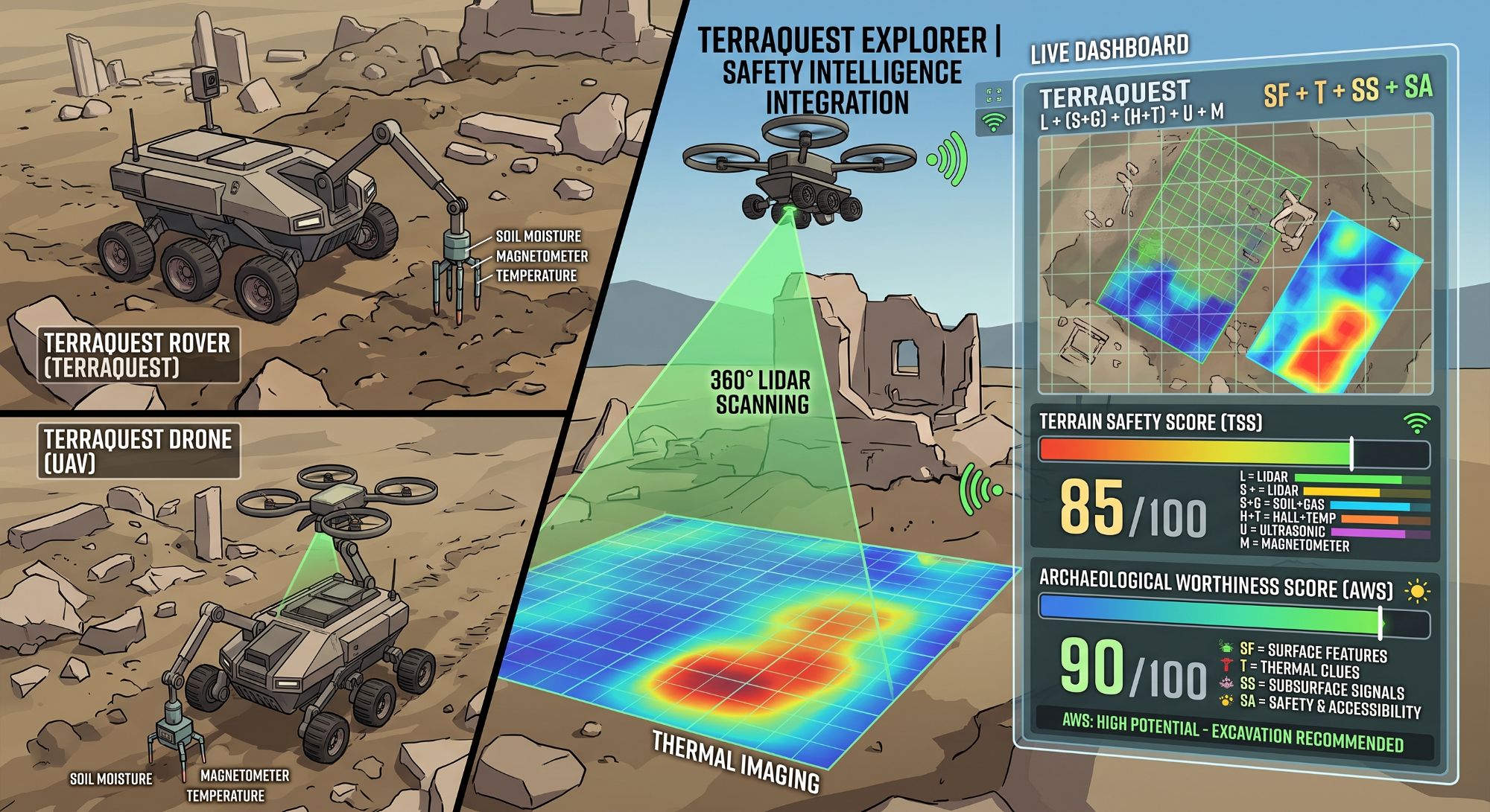
TerraQuest Explorer rover and drone hardware, LiDAR and thermal scanning, and the live mission dashboard showing Terrain Safety and Archaeological Worthiness scores
Ground Control
Cloud Dashboard / Web UI

Live mission telemetry, mapping visualization, and remote command interface.

⟷
Aerial Recon
Remote Drone / UAV

Overhead survey pass to pre-scout terrain before ground deployment.

▼
Telemetry & Command via TCP/IP · WiFi / Internet
Compute Layer — "The Brain"
Raspberry Pi 5
  • Edge AI / Small Language Model (SLM) for offline decision-making
  • Algorithm processing — Terrain Safety & Archaeological Worthiness scores
  • Computer vision processing (front / rear cameras)
  • Cloud client & onboard data storage
▼
Serial Communication / USB
Sensor Layer — "The Nervous System"
Arduino Uno R4 WiFi — I2C / GPIO Interface Manager
  • 360° LiDAR & ultrasonic sensors — spatial mapping & edge detection
  • GPS module — geospatial tracking
  • Magnetometer & Hall-effect sensor — buried metal / anomaly detection
  • Soil moisture sensor — terrain sink risk
  • Gas, smoke & temperature/humidity sensors — environmental safety
▼
PWM / Motor Control
Locomotion Layer — "The Muscle"
L298N / PCA9685 Motor Driver
  • 4WD Mecanum wheel chassis — omnidirectional cave & rubble navigation
Shipped sensor suite live in the open-source repo:VL53L4CD ToFMLX90640 ThermalLTR390 UV/LightMMC5983MA MagnetometerBME688 Env.View Source ↗

Predictive Scoring Algorithms

The core intellectual property of the TerraQuest Explorer is its ability to translate raw environmental data into actionable intelligence. I mentored the students in developing two proprietary algorithms.

1. Terrain Safety Score (TSS)

Calculated on a 0–100 scale, this algorithm determines if a site is physically safe for the rover and human entry.

TSS = L + (S+G) + (H+T) + U + M

Data points: LiDAR (slope/roughness), Soil + Gas (sink and respiratory risks), Hall-effect + Temperature (magnetic/structural stability), Ultrasonic (edge/cliff detection), and Magnetometer (geologic interference).

2. Archaeological Worthiness Score (AWS)

This metric predicts the likelihood of finding historical artifacts, allowing researchers to optimize their excavation budgets.

AWS = SF + T + SS + SA

Data points: Surface Features (LiDAR anomalies), Thermal Clues (voids and tombs), Subsurface Signals (metal/brick detection), and the Safety & Accessibility Score (derived from the TSS).

Real-World Impact

This project demonstrated that youth robotics can move beyond theory into real-world application. Through rigorous design, expert collaboration, and complex systems architecture, these middle schoolers proved they are not just learning technology — they are contributing viable, scalable solutions to global industries.

Explore the Repository ↗